

Reconditioned Laser Scanners
Looking for a cost-effective solution for your scanning needs? Look no further than Sunbelt Sales' range of reconditioned laser scanners. We offer a variety of used laser scanners at highly competitive prices, all fully serviced and maintained to the highest standards. Our pre-owned scanners are manufactured by leading suppliers such as Leica and Faro, ensuring quality and reliability.
Whether you're in the construction industry, engineering field, or any other profession that requires precise scanning, our reconditioned laser scanners are the perfect choice. With our affordable options, you don't have to compromise on quality or accuracy.
Shop our selection of used laser scanners today and find the perfect one for your scanning needs. And with free delivery on all orders over £30 in mainland UK, it's never been easier to get your hands on top-notch scanning equipment from Sunbelt Sales.
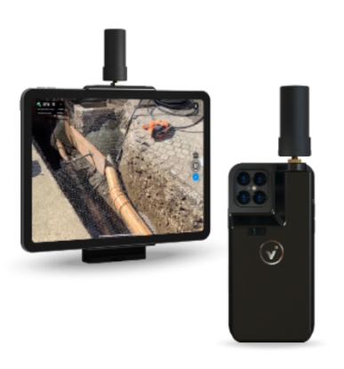
The viDoc RTK rover is the ideal ground image acquisition device. It geotags images collected with PIX4Dcatch in real-time when connected to any NTRIP service, allowing for absolute accuracy (under 5 cm) during ground data collection and surveying.
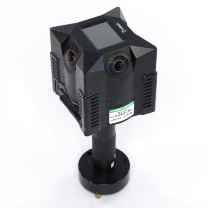
Designed for rapid 360º imaging, iSTAR Fusion is a panoramic camera that precisely captures full spherical immersive images and high resolution panoramic data streams for efficient visual documentation of an environment.
Use to supplement laser scanning point cloud capture - the fasster HDR photo capture of the iStar Fusion than many built-in cameras within terrestrial laser scanners helps speed up scanning workflows.
Or even produce 3D point clouds without the need for a laser scanner.
