

Surveying Instruments
Looking for high-quality surveying instruments? Look no further than Sunbelt Sales. We offer one of the widest ranges of surveying equipment for sale in the UK. Whether you need total stations, 3D survey laser scanners, UAVs, theodolites, GNSS surveying equipment, construction lasers, levels, machine control equipment, utility detectors, or any other surveying instrument, we have it all.
As an authorised distributor and service partner of Leica Geosystems, and a distribution partner of both FARO Technologies and Radiodetection, you can trust that our surveying equipment is reliable and top-notch. We pride ourselves on providing the best products at competitive prices.
With Sunbelt Sales, you can buy with confidence. We offer free delivery in mainland UK on all orders over £30. So why wait? Browse our range of surveying equipment and find the perfect instrument for your needs today.
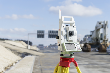
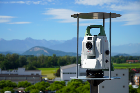
Total Stations
Looking for a complete site solution? Our Total Stations are the perfect tool for accurate and efficient measurements with minimal hassle. Equipped with advanced angle, distance, and reflectorless technology, our range of Total Stations offers unsurpassed accuracy and reliability.
Whether you need a manual total station or a one-person operated kit, we have a full range of models to suit your project requirements. Our expert team can provide pre-project consultation to help you find the most suitable instruments for your work.
At Sunbelt Sales, we go beyond just selling Total Stations. If you need assistance with setup or support throughout your project, our team is here to help. We also offer a Survey Support Service to provide you with even more resources and expertise.
Ready to find the perfect Total Station for your needs? Call our expert team at 0330 175 9558 for personalized advice and recommendations.
Discover more about our Survey Support Service here>>
Shop our range of Total Stations products from Sunbelt Sales today and enjoy free delivery on all orders over £30 in mainland UK.
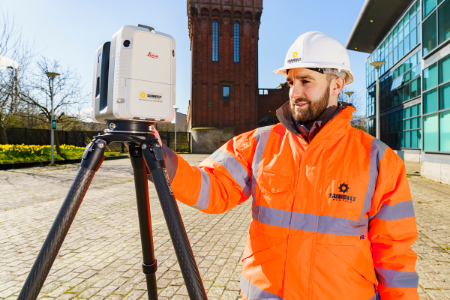
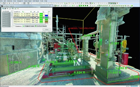
3D Laser Scanning
Looking for a reliable and efficient way to collect accurate spatial data? Look no further than our range of 3D Laser Scanning Surveying Equipment at Sunbelt Sales. Laser scanning has become increasingly popular in industries such as surveying, film, and archaeology, where time on site is limited.
Our laser scanners can collect millions of individual point measurements within minutes, creating a detailed 'point cloud' of an object's external surface. By combining multiple data clouds collected from different viewpoints, you can create a comprehensive 3D dataset. This data can be used for visualisation, modelling, planning, and more.
But that's not all - our 3D Laser Scanning Surveying Equipment can also be used for BIM, geomorphological change analysis, heritage projects, and mapping pipes and cables. The possibilities are endless!
Ready to take your surveying capabilities to the next level? Browse our range of 3D Laser Scanning Surveying Equipment and enjoy free delivery on all orders over £30 within mainland UK.
To find out more about our Survey Support Service, click here>>
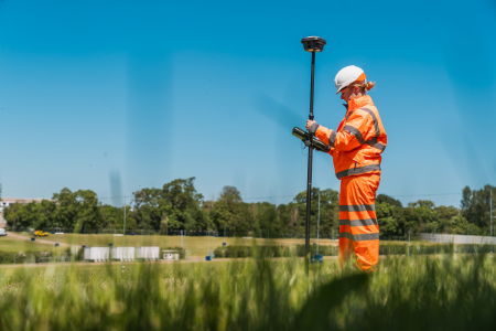
GNSS Systems
Looking for high-quality GNSS surveying systems? Look no further than Sunbelt Sales. Our GNSS systems combine cutting-edge technology with powerful data management capabilities to provide you with accurate and reliable results.
With the Leica Viva GNSS range, you can choose from fully integrated or modular systems, giving you the flexibility you need for your surveying projects. These systems take advantage of four major satellite constellations - GPS, GLONASS, Galileo, and BeiDou - ensuring optimal performance and accuracy.
At Sunbelt Sales, we are committed to providing you with the best survey equipment on the market. Browse our range of GNSS systems and find the perfect solution for your surveying needs. And don't forget, we offer free delivery on all orders over £30 in mainland UK.
Interested in our Survey Support Service? Click here to find out more>>

GIS Asset Collection
Looking for reliable and high-quality products to geo-enable your mobile workforces? Look no further than the Leica Zeno GIS series from Sunbelt Sales.
The Zeno GIS series by Leica Geosystems offers a wide range of hardware and software solutions for all your Asset Collection & Management needs. With easy-to-use and customizable options, you can enhance your performance and increase profitability by simplifying data integration from the field to the office.
Efficient workflows are ensured with the Zeno GIS series, as it reduces trips from the field to the office and allows for real-time monitoring of captured data. Whether you need completely integrated handheld devices, tablet computers, or modular solutions, the Zeno GIS series has you covered for all your tasks.
Explore our range of GIS Asset Collection Products at Sunbelt Sales and enjoy free delivery in mainland UK on all orders over £30.
Click here to find out more about our Survey Support Service.
Software
Looking for software packages to enhance your airborne surveying equipment? Look no further! At Sunbelt Sales, we offer a range of software packages designed to work seamlessly with Unmanned Aerial Vehicles (UAV's) and other surveying equipment. As UAV's gain popularity in the industry, our software solutions are here to support your needs.
Our software offerings include crane camera solutions, drone-based mapping software, AutoCAD plug-ins, digital leveling suites, specialist apps, and much more. With our diverse range of options, you can find the perfect software to optimize your surveying operations.
For more information about our Survey Support Service, click here>>
Experience the convenience and efficiency of our Surveying Equipment Software from Sunbelt Sales. Browse our selection today and take advantage of our free delivery in mainland UK on all orders over £30.

Levels & Lasers
Looking for high-quality surveying levels and lasers? Look no further than Sunbelt Sales. We offer a wide range of surveying levels, including automatic, digital, and precise levels, designed for accurate levelling tasks in surveying.
Our selection includes the latest models from Leica Geosystems, ensuring exceptional precision even in extreme light conditions. Whether you need a level for daily tasks or advanced levelling work, our levels can be configured to suit your preferences. With features like touchscreen technology, automation, and shock-resistant housing, you can rely on our levels for any project.
In addition to levels, we also stock a variety of lasers for various applications and industries. From construction lasers to grade lasers, pipe lasers, and line and dot lasers, we have the right laser for your needs. These portable measuring instruments are widely used in construction, utilities, and interior fittings, enhancing productivity and efficiency.
Our latest lasers include upgradable rotating lasers, which can be adapted to any application through software upgrades. With excellent performance in levelling, aligning, and squaring tasks, these lasers are a valuable addition to any toolkit.
Shop our range of Levels & Lasers at Sunbelt Sales today and enjoy free delivery on all orders over £30 in mainland UK. Find the perfect tools for your surveying needs and achieve accurate results every time.
Monitoring
At Sunbelt Sales, we offer a diverse selection of monitoring equipment to meet your needs. Whether you need to monitor the movement of structures, on-site noise, particulate levels, or vibration levels, we have the perfect solutions for you.
Our range of monitoring surveying equipment is designed to help you remain compliant with local environmental legislation and standards. With our high-quality products, you can ensure accurate and reliable monitoring results.
Shop with confidence at Sunbelt Sales, where we prioritize customer satisfaction and offer free delivery on all orders over £30 in mainland UK. Explore our range of monitoring equipment today and find the perfect solution for your monitoring needs.