

3D Laser Scanning
Looking for a reliable and efficient way to collect accurate spatial data? Look no further than our range of 3D Laser Scanning Surveying Equipment at Sunbelt Sales. Laser scanning has become increasingly popular in industries such as surveying, film, and archaeology, where time on site is limited.
Our laser scanners can collect millions of individual point measurements within minutes, creating a detailed 'point cloud' of an object's external surface. By combining multiple data clouds collected from different viewpoints, you can create a comprehensive 3D dataset. This data can be used for visualisation, modelling, planning, and more.
But that's not all - our 3D Laser Scanning Surveying Equipment can also be used for BIM, geomorphological change analysis, heritage projects, and mapping pipes and cables. The possibilities are endless!
Ready to take your surveying capabilities to the next level? Browse our range of 3D Laser Scanning Surveying Equipment and enjoy free delivery on all orders over £30 within mainland UK.
To find out more about our Survey Support Service, click here>>
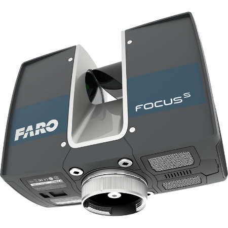
3D Scanners
Looking to create accurate and detailed 3D models? Look no further than Sunbelt Sales' range of 3D Scanners. These revolutionary devices offer non-contact scanning for precise 3D modeling and documentation. With an integrated touchscreen display, operating these scanners is simple and intuitive.
Our 3D laser scanners are designed to be user-friendly, with a compact size and lightweight construction. This not only makes them easy to handle but also allows for faster scanning compared to traditional scanners. Say goodbye to lengthy scanning times and hello to efficient 3D modeling.
At Sunbelt Sales, we offer a variety of 3D Scanners for all your surveying needs. Whether you're a professional in the field or a hobbyist looking to explore the world of 3D modeling, our range has something for everyone. Plus, enjoy free delivery on all orders over £30 within mainland UK.
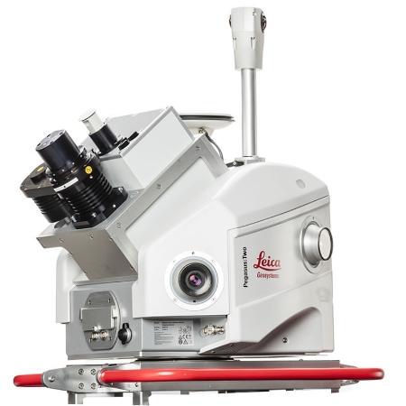
Mobile Mapping
Are you in need of accurate and efficient surveying equipment for road mapping? Look no further than Sunbelt Sales' range of Mobile Mapping Surveying Equipment.
Traditionally, surveying UK roads with absolute accuracy has been a challenge. However, with the introduction of Mobile Mapping equipment, this challenge can be overcome. Our Mobile Mapping equipment utilizes laser scanning technology to capture Survey Grade 3D point clouds and calibrated 360° imagery while in motion.
One of the key advantages of our Mobile Mapping platform is its ease of use. The equipment is mounted directly to the roof of a vehicle, eliminating the need for traffic management and ensuring safe and efficient data capture of roads, hazardous environments, and construction sites.
With advanced imagery, measurement capture tools, and a variety of mobile transportation platforms, our 3D Mobile Mapping equipment enables users to visualize, record, measure, and understand environments like never before.
In addition to our larger Mobile Mapping instruments, we also offer smaller wearable and handheld devices. These compact devices are perfect for surveying difficult-to-reach areas or buildings where time and space limitations are a factor, such as underground locations.
Discover the power of Mobile Mapping Surveying Equipment from Sunbelt Sales. Browse our range today and enjoy free delivery on all orders over £30 within mainland UK.

Software
Looking for the best software for your 3D Laser Scanning Surveying Equipment? Look no further than Sunbelt Sales. We offer a wide range of top-quality software to meet all your surveying needs.
At Sunbelt Sales, we understand the importance of having reliable and efficient software for your surveying equipment. That's why we only offer the best brands and products that are trusted by professionals in the industry.
Whether you need software for data processing, point cloud registration, or modeling, we have you covered. Our software is designed to help you streamline your workflow, improve accuracy, and save time on your projects.
With our user-friendly interface and advanced features, you can easily analyze and visualize your survey data with precision. Our software is compatible with a wide range of surveying equipment, ensuring seamless integration and optimal performance.
Shop with confidence at Sunbelt Sales. Our team of experts is always ready to assist you in finding the perfect software for your specific needs. Plus, with our free delivery on mainland UK orders over £30, you can enjoy the convenience of having your software delivered right to your doorstep.
Choose Sunbelt Sales for all your 3D Laser Scanning Surveying Equipment Software needs. Experience the difference of quality and reliability. Shop now!
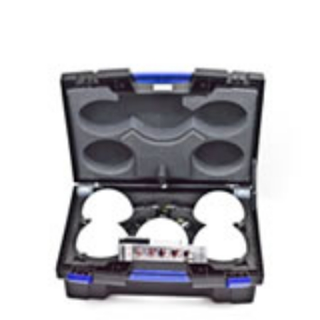
Accessories
Looking for accessories to enhance your 3D laser scanning experience? Look no further than Sunbelt Sales. As a trusted supplier of high-quality survey equipment and hardware, we offer a range of 3D laser scanning accessories to meet your needs.
Whether you're a professional surveyor or a hobbyist, our accessories are designed to help you get the most out of your scanning equipment. From tripods and targets to calibration panels and carrying cases, we have everything you need to ensure accurate and efficient scanning.
At Sunbelt Sales, we understand the importance of reliable equipment. That's why we only offer accessories from reputable brands known for their durability and precision. You can trust that our products will withstand the rigors of the field and deliver consistent results.
With our user-friendly website and competitive prices, it's never been easier to find the perfect 3D laser scanning accessories. Plus, with free delivery on all orders over £30 in mainland UK, you can shop with confidence knowing you're getting a great deal.
Take your 3D laser scanning to the next level with accessories from Sunbelt Sales. Explore our range today and discover the tools that will elevate your scanning projects.
Leica BLK Equipment
Looking for top-quality surveying equipment? Look no further than Sunbelt Sales. We offer a wide range of Leica BLK Surveying Equipment to meet all your needs. Whether you're a professional surveyor or a DIY enthusiast, our products are designed to deliver accurate and reliable results.
At Sunbelt Sales, we understand the importance of having the right tools for the job. That's why we only stock the best equipment from trusted brands like Leica. Our Leica BLK Surveying Equipment is known for its precision, durability, and advanced features. From laser scanners to total stations, we have everything you need to complete your surveying projects with ease.
When you shop with us, you can expect competitive prices and excellent customer service. We are committed to providing our customers with the highest level of satisfaction. Plus, with free delivery on all orders over £150 in mainland UK, you can enjoy even more value for your money.
Don't settle for subpar surveying equipment. Choose Sunbelt Sales for top-of-the-line Leica BLK Surveying Equipment that will help you get the job done right. Explore our range today and take your surveying projects to the next level.